Soil type is a crucial factor in determining the attributes of a zone. Different soil types have varying water capacities, directly influencing the watering duration and frequency in an ET smart schedule. Accurate characterization of soil type attributes is vital for creating an effective ET smart schedule. The following provides a simple and practical method to identify soil types in different zones.
What is Soil Texture?
To begin, let's gain an understanding of soil texture. Soil texture is determined by the size of mineral particles present in the soil, including Sand, Silt, and Slay.
. Sand consists of the largest and coarsest mineral particles, ranging from 2.00 to 0.05 mm in diameter. It has a gritty texture when rubbed between your fingers.
. Silt particles are smaller, ranging from 0.05 to 0.002 mm, and have a texture similar to dry flour.
. Clay particles are extremely fine, smaller than 0.002 mm. When wet, they feel sticky and tend to clump together, making it difficult to distinguish individual particles.
The proportions of these mineral particle sizes in the soil determine its texture.
What is Soil Texture Triangle?
The Soil Texture Triangle, also known as the USDA Soil Textural Triangle, is a graphical tool used to classify soil textures based on the proportions of sand, silt, and clay particles in the soil. It provides a visual representation of different soil types based on these proportions. The triangle is divided into sections representing specific soil texture classifications, such as sandy loam, silty clay, or clay loam. By determining the percentages of sand, silt, and clay in a soil sample and plotting them on the triangle, one can identify the corresponding soil texture classification.
The Soil Texture Triangle is widely used in soil science, agriculture, and engineering to understand soil properties and make informed decisions regarding irrigation, drainage, and land use. It helps in assessing water holding capacity, permeability, and other characteristics crucial for plant growth and soil management. The triangle simplifies the process of soil texture classification, providing a practical and standardized approach to categorizing different soil types based on their particle size distribution.
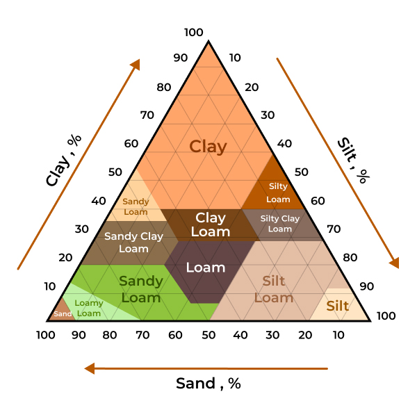
USDA Soil Textural Triangle
Identify your soil type.
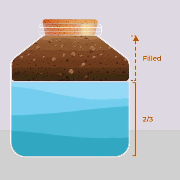
1. Fill a transparent container with about two-thirds of water. Then, add enough soil to almost fill the jar. You can also add a small amount of laundry detergent to aid in better separation of soil components. Shake the jar vigorously and then place it in an undisturbed location.
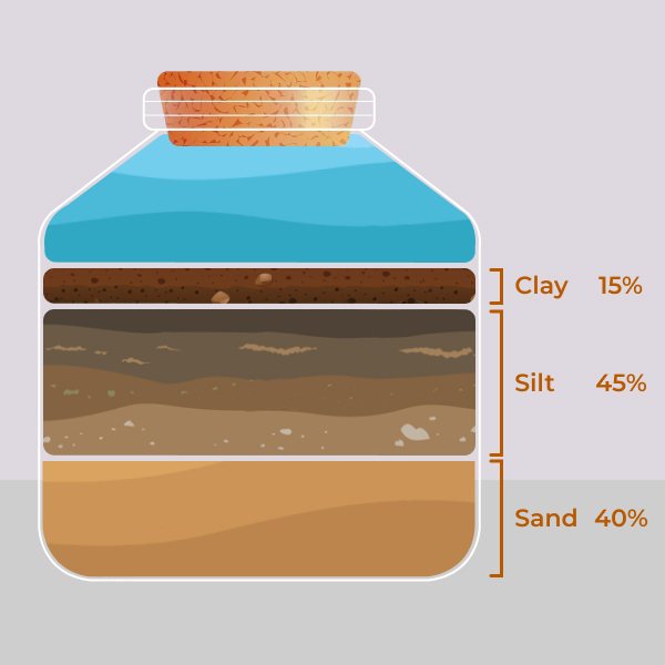
2. Observe the jar over the next few days as the particles will start to stratify. Larger sand particles will settle at the bottom, followed by a layer of silt, and then a layer of clay. The clay may remain suspended and make the water turbid for several days, which is why the sample needs to be left undisturbed. Organic matter may float on the surface or sink to the bottom of the water.
Measure the height of each layer and the total height of the soil. Then, by dividing the height of each component by the sample's height, you can make a preliminary estimation of the relative content of sand, silt, and clay in the soil. In the following example, the three components account for 15%, 45%, and 40% of the total, respectively.
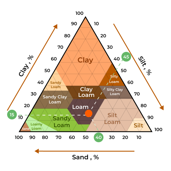
3. By utilizing the Soil Texture Triangle provided by the Natural Resources Conservation Service of the United States Department of Agriculture, soil types can be determined by plotting the percentages of the three soil components and connecting the points to identify the specific soil type. As shown in the diagram below, the intersection of the three lines falls within the "Loam" region, indicating that the detected soil type is "Loam."
Set the Soil Type attribute.
You will find that we do not provide so many soil types for you to choose from, because in general, you are unlikely to have a zone that is all silt. The options we provide basically cover all the soil types that residential areas will have. If you find that the soil type tested is not within the range of options provided, please select “Others” and then manually enter the value of “Available Water”.
If highly accurate results are required, it is recommended to seek the assistance of professionals.
Still need help?
In case the above method doesn’t work for you, please contact our technical support team directly using the contact information below. We will respond to you by email within 12h after your message reaches us.
Email: Support@imolaza.com